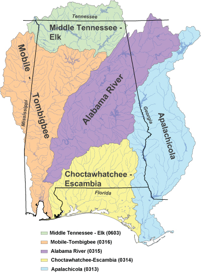
Strategic Habitat Units in the following hydrologic unit (HU)-4 sub-regions in Alabama were identified to focus conservation activities for managing, recovering, and restoring populations of rare fishes, mussels, snails, and crayfishes.
Sub-regions
Middle Tennessee-Elk
The Tennessee River begins in Virginia, flows south and dips into Alabama, and ends in
Kentucky where it
joins the Ohio River. This sub-region is 10,355 mi
2 in size and contains
the major tributaries of Bear Creek, Cypress Creek, Limestone Creek, Shoal Creek, Flint
River, and the Paint Rock River. The Highland Rim physiographic section makes up the
majority of this sub-region which results in the highest concentration of karst in the state.
Mobile-Tombigbee
The Mobile-Tombigbee sub-region in the Cumberland Plateau and Fall Line Hills
physiographic sections falls in Mississippi and Alabama and is 21,889 mi2. Major
waterways in this basin include the Black Warrior River, Sipsey River, North River,
Locust Fork, and the Tombigbee River. The manmade channel that connects the
Tennessee River drainage to the Tombigbee River draining is the Tennessee –
Tombigbee Waterway, also known as the Tenn – Tom. It is an important navigational
route for barge traffic to reach the Gulf of Mexico. This sub-region, as well as the
Alabama River sub-region, drains into the highly productive and diverse Mobile Delta.
Alabama
The Alabama sub-region begins in Georgia and ends in Alabama in the Mobile Delta.
Covering 22,655 square miles, the Alabama sub-region includes the Coosa River, the Tallapoosa River, and the
Cahaba River. These rivers have higher minerality and clarity than those of the Cumberland Plateau and the Coastal Plain because of the Valley and Ridge and the Piedmont physiographic features. A large number of manmade reservoirs pepper the basin and are known for quality fishing opportunities.
Choctawhatchee-Escambia
The Choctawhatchee-Escambia sub-region is entirely in Alabama's coastal drainage system and flows into the Gulf of Mexico. It is 14,342 square miles in size and includes the Conecuh River, Murder Creek, the Pea River, and the Choctawhatchee River. This sub-region can be identified by rolling hills, slow and muddy to sandy bottom streams, and broad alluvial floodplains.
Apalachicola
The Apalachicola sub-region is 20,198 mi2 and falls in Georgia, Florida, and Alabama.
Main rivers that flow through its watershed include the Apalachicola River, the Chipola River, and
Uchee Creek. This sub-region begins in the Appalachian Mountains and ends in the Gulf of Mexico.